Words on Wednesday
Words on Wednesday: Poroelastic responses of confined aquifers to subsurface strain changes and their use for volcano monitoring
Words on Wednesday aims at promoting interesting/fun/exciting publications on topics related to Energy, Resources and the Environment. If you would like to be featured on WoW, please send us a link of the paper, or your own post, at ERE.Matters@gmail.com.
***
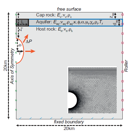
Strehlow, K., Gottsmann, J. H., and Rust, A. C., 2015. Poroelastic responses of confined aquifers to subsurface strain changes and their use for volcano monitoring, Solid Earth Discuss., 7, 1673-1729, doi:10.5194/sed-7-1673-2015.
Abstract:
Well water level changes associated with magmatic unrest can be interpreted as a result of pore pressure changes in the aquifer due to crustal deformation, and so could provide constraints on the subsurface processes causing this strain. We use Finite Element Analysis to demonstrate the response of aquifers to volumetric strain induced by pressurised magma reservoirs. Two different aquifers are invoked – an unconsolidated pyroclastic deposit and a vesicular lava flow – and embedded in an impermeable crust, overlying a magma chamber. The time-dependent, fully coupled models simulate crustal deformation accompanying chamber pressurisation and the resulting hydraulic head changes as well as porous flow in the aquifer. The simulated deformational strain leads to centimetres (pyroclastic aquifer) to meters (lava flow aquifer) of hydraulic head changes; both strain and hydraulic head change with time due to substantial porous flow in the hydrological system. Well level changes are particularly sensitive to chamber volume and shape, followed by chamber depth and the phase of the pore fluid. The Young’s Modulus and permeability of the aquifer, as well as the strength of pressurisation also have significant influence on the hydraulic head signal. While source characteristics, the distance between chamber and aquifer and the elastic stratigraphy determine the strain field and its partitioning, flow and coupling parameters define how the aquifer responds to this strain and how signals change with time. We investigated a period of pre-eruptive head changes recorded at Usu volcano, Japan, where well data were interpreted using an analytical deformation model. We find that generic analytical models can fail to capture the complex pre-eruptive subsurface mechanics leading to well level changes, due to aquifer pressure changes being sensitive to chamber shape and lithological heterogeneities. In addition, the presence of a pore fluid and its flow have a significant influence on the strain signal in the aquifer and are commonly neglected in analytical models. These findings highlight the need for numerical models for the interpretation of observed well level signals. However, simulated water table changes do mirror volumetric strain and wells can therefore serve as comparatively cheap strain meters that could provide important insights into pre-eruptive dynamics.
Words on Wednesday: Effects of soil settlement and deformed geometry on a historical structure
Words on Wednesday aims at promoting interesting/fun/exciting publications on topics related to Energy, Resources and the Environment. If you would like to be featured on WoW, please send us a link of the paper, or your own post, at ERE.Matters@gmail.com.
***
Yardım, Y. and Mustafaraj, E., 2015. Effects of soil settlement and deformed geometry on a historical structure, Nat. Hazards Earth Syst. Sci., 15, 1051-1059, doi:10.5194/nhess-15-1051-2015.
Abstract:
Protecting the historical character of a valued structure during the assessment and damage repair process is a very challenging task for many engineers. Heritage protection is complicated by a lack of design details and restrictions on sample extraction needed to obtain accurate material properties and limited studies on the restoration of certain types of historical structures. This study aims to assess the effects of soil settlement on a structure’s stress concentrations and the value of laser scanning techniques on structure analysis in obtaining correct data of settlement vs. deformation. Terrestrial laser scanner (TLS) data are used to analyse the 500-year-old historical structure of Naziresha’s Mosque. The obtained TLS data allow an accurate definition of the imperfect geometry patterns lying on every side of the structure. The soil profile and general crack formation together with TLS measurement proves that the structure deformed toward the south façade, where a railway and motorway are also located. Stress concentration and mode period results have a considerable difference, which highlights earthquake vulnerability and failure mechanisms and changes the strategy of possible retrofitting.

Words on Wednesday: The ocean carbon sink – impacts, vulnerabilities and challenges
Words on Wednesday aims at promoting interesting/fun/exciting publications on topics related to Energy, Resources and the Environment. If you would like to be featured on WoW, please send us a link of the paper, or your own post, at ERE.Matters@gmail.com.
***
Heinze, C., Meyer, S., Goris, N., Anderson, L., Steinfeldt, R., Chang, N., Le Quéré, C., and Bakker, D. C. E., 2015. The ocean carbon sink – impacts, vulnerabilities and challenges, Earth Syst. Dynam., 6, 327-358, doi:10.5194/esd-6-327-2015.
Abstract:
Carbon dioxide (CO2) is, next to water vapour, considered to be the most important natural greenhouse gas on Earth. Rapidly rising atmospheric CO2 concentrations caused by human actions such as fossil fuel burning, land-use change or cement production over the past 250 years have given cause for concern that changes in Earth’s climate system may progress at a much faster pace and larger extent than during the past 20 000 years. Investigating global carbon cycle pathways and finding suitable adaptation and mitigation strategies has, therefore, become of major concern in many research fields. The oceans have a key role in regulating atmospheric CO2 concentrations and currently take up about 25% of annual anthropogenic carbon emissions to the atmosphere. Questions that yet need to be answered are what the carbon uptake kinetics of the oceans will be in the future and how the increase in oceanic carbon inventory will affect its ecosystems and their services. This requires comprehensive investigations, including high-quality ocean carbon measurements on different spatial and temporal scales, the management of data in sophisticated databases, the application of Earth system models to provide future projections for given emission scenarios as well as a global synthesis and outreach to policy makers. In this paper, the current understanding of the ocean as an important carbon sink is reviewed with respect to these topics. Emphasis is placed on the complex interplay of different physical, chemical and biological processes that yield both positive and negative air–sea flux values for natural and anthropogenic CO2 as well as on increased CO2 (uptake) as the regulating force of the radiative warming of the atmosphere and the gradual acidification of the oceans. Major future ocean carbon challenges in the fields of ocean observations, modelling and process research as well as the relevance of other biogeochemical cycles and greenhouse gases are discussed.

monthly 11 degree gridded data set (Bakker et al., 2014). The maps were generated by using the online Live Access Server.
Words on Wednesday: Do Himalayan treelines respond to recent climate change? An evaluation of sensitivity indicators
Words on Wednesday aims at promoting interesting/fun/exciting publications on topics related to Energy, Resources and the Environment. If you would like to be featured on WoW, please send us a link of the paper, or your own post, at ERE.Matters@gmail.com.
***
Schickhoff, U., Bobrowski, M., Böhner, J., Bürzle, B., Chaudhary, R. P., Gerlitz, L., Heyken, H., Lange, J., Müller, M., Scholten, T., Schwab, N., and Wedegärtner, R., 2015. Do Himalayan treelines respond to recent climate change? An evaluation of sensitivity indicators, Earth Syst. Dynam., 6, 245-265.
Abstract:

Several sensitivity indicators such as treeline type, treeline form, seed-based regeneration, and growth patterns are evaluated. Since most Himalayan treelines are anthropogenically depressed, observed advances are largely the result of land use change. Near-natural treelines are usually krummholz treelines, which are relatively unresponsive to climate change. Nevertheless, intense recruitment of treeline trees suggests a great potential for future treeline advance. Competitive abilities of seedlings within krummholz thickets and dwarf scrub heaths will be a major source of variation in treeline dynamics. Tree growth–climate relationships show mature treeline trees to be responsive to temperature change, in particular in winter and pre-monsoon seasons. High pre-monsoon temperature trends will most likely drive tree growth performance in the western and central Himalaya. Ecological niche modelling suggests that bioclimatic conditions for a range expansion of treeline trees will be created during coming decades.

Words on Wednesday: Farmers’ perceptions of and adaptation strategies to climate change and their determinants: the case of Punjab province, Pakistan
Words on Wednesday aims at promoting interesting/fun/exciting publications on topics related to Energy, Resources and the Environment. If you would like to be featured on WoW, please send us a link of the paper, or your own post, at ERE.Matters@gmail.com.
***
Abid, M., Scheffran, J., Schneider, U. A., and Ashfaq, M., 2015. Farmers’ perceptions of and adaptation strategies to climate change and their determinants: the case of Punjab province, Pakistan, Earth Syst. Dynam., 6, 225-243.
Abstract:
Climate change is a global environmental threat to all economic sectors, particularly the agricultural sector. Pakistan is one of the countries negatively affected by climate change due to its high exposure to extreme events and low adaptive capacity. In Pakistan, farmers are the primary stakeholders in agriculture and are more at risk due to climate vulnerability. Based on farm household data from 450 households collected from three districts in three agroecological zones in the Punjab province of Pakistan, this study examines how farmers perceive climate change and how they adapt their farming in response to perceived changes in climate. The results demonstrate that awareness of climate change is widespread throughout the area, and farm households make adjustments to adapt their agriculture in response to climatic change. Overall 58% of the farm households adapted their farming to climate change. Changing crop varieties, changing planting dates, planting of shade trees and changing fertilizers were the main adaptation methods implemented by farm households in the study area. The results from the binary logistic model reveal that education, farm experience, household size, land area, tenancy status, ownership of a tube well, access to market information, information on weather forecasting and agricultural extension services all influence farmers’ choices of adaptation measures. The results also indicate that adaptation to climate change is constrained by several factors such as lack of information, lack of money, resource constraints and shortage of irrigation water in the study area. Findings of the study suggest the need for greater investment in farmer education and improved institutional setup for climate change adaptation to improve farmers’ wellbeing.

Words on Wednesday: Cobalt, chromium and nickel contents in soils and plants from a serpentinite quarry
Words on Wednesday aims at promoting interesting/fun/exciting publications on topics related to Energy, Resources and the Environment. If you would like to be featured on WoW, please send us a link of the paper, or your own post, at ERE.Matters@gmail.com.
***
Lago-Vila, M., Arenas-Lago, D., Rodríguez-Seijo, A., Andrade Couce, M. L., and Vega, F. A., 2015. Cobalt, chromium and nickel contents in soils and plants from a serpentinite quarry, Solid Earth, 6, 323-335.
Abstract:
The former serpentinite quarry of Penas Albas (Moeche, Galicia, NW Spain) left behind a large amount of waste material scattered over the surrounding area, as well as tailing areas. In this area several soils were studied together with the vegetation growing spontaneously over them with the aim of identifying the bioavailability of heavy metals. The potential of spontaneous vegetation for phytoremediation and/or phytostabilization was evaluated. The pH of the soils ranges from neutral to basic, with very low organic matter and nitrogen contents. There are imbalances between exchangeable cations like potassium (K) and calcium (Ca), mainly due to high magnesium (Mg) content that can strongly limit plant production. Moreover, in all of the studied soils there are high levels of cobalt (Co), chromium (Cr) and nickel (Ni) (>70, >1300 and >1300 mg kg-1, respectively). They exceed the intervention limits indicated by soil guideline values. Different soil extractions were performed in order to evaluate bioavailability. CaCl2⋅0.01M is the most effective extraction reagent, although the reagent that best predicts plant availability is a mixture of low molecular weight organic acids. Festuca rubra, L. is the spontaneous plant growing in the soils that accumulates the highest amount of the metals, both in shoot and roots. Festuca also has the highest translocation factor values, although they are only >1 for Cr. The bioconcentration factor is >1 in all of the cases, except in the shoot of Juncus sp. for Co and Ni. The results indicate that Festuca is a phytostabilizer of Co and Ni and an accumulator of Cr, while Juncus sp. is suitable for phytostabilization.
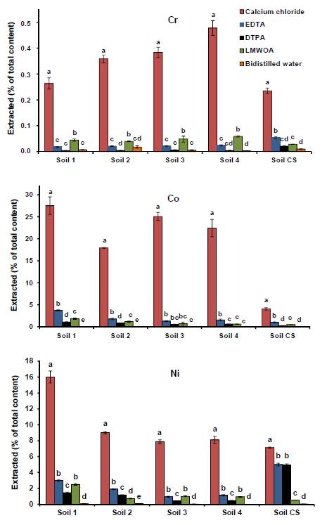
indicate significantly different EF values (p <0.05) for each
metal. Hanging bars are the standard deviation.
Words on Wednesday: Flow-through experiments on water–rock interactions in a sandstone caused by CO2 injection at pressures and temperatures mimicking reservoir conditions
Words on Wednesday aims at promoting interesting/fun/exciting publications on topics related to Energy, Resources and the Environment. If you would like to be featured on WoW, please send us a link of the paper, or your own post, at ERE.Matters@gmail.com.
This week, we would like to share with you the latest manuscript of Farhana Huq, who was our guest-blogger on Monday! 🙂
***
Huq, F., S.B. Haderlein, O.A. Cirpka, M. Nowak, P. Blum, P. Grathwohl, 2015. Flow-through experiments on water–rock interactions in a sandstone caused by CO2 injection at pressures and temperatures mimicking reservoir conditions. Applied Geochemistry, v58, 136–146.
Highlights:
- Altmark sandstone showed CO2-induced fluid–rock interactions under in-situ conditions.
- Dissolution of anhydrite and calcite cements was inferred from fluid analysis.
- Sample permeability increased by a factor 2.
Abstract:
Flow-through experiments were performed in a newly designed experimental setup to study the water–rock interactions caused by CO2 injection in sandstones obtained from the Altmark natural gas reservoir under the simulated reservoir conditions of 125°C and 50 bar CO2 partial pressure. Two different sets of experiments were conducted using CO2-saturated millipore water and CO2-saturated brine (41.62 g L-1 NaCl and 31.98 g L-1 CaCl2·2H2O), mimicking the chemical composition of the reservoir formation water. The major components in the sandstone were quartz (clasts + cement), feldspars, clay minerals (illite and chlorite), and cements of carbonates and anhydrite. Fluid analysis suggested the predominant dissolution of anhydrite causing increased concentrations of calcium and sulfate at early time periods at non-equilibrium geochemical conditions. The Ca/SO4 molar ratio (>1) indicated the concurrent dissolution of both calcite and anhydrite. Dissolution of feldspar and minor amounts of clay (chlorite) was also evident during the flow-through experiments. The permeability of the sample increased by a factor of two mostly due to the dissolution of rock cements during brine injection. Geochemical modeling suggests calcite dissolution as the major buffering process in the system. The results may in future studies be used for numerical simulations predicting CO2 storage during injection in sandstone reservoirs.

What to see at EGU?: Words on Wednesday – The Green River Natural Analogue as A Field Laboratory To Study the Long-term Fate of CO2 in the subsurface
Words on Wednesday aims at promoting interesting/fun/exciting publications on topics related to Energy, Resources and the Environment. If you would like to be featured on WoW, please send us a link of the paper, or your own post, at ERE.Matters@gmail.com.
If you are interested in today’s WoW, some of the results will be presented during the EGU in session ERE5.2 Field methods and analysis of field data for CO2 geological storage, on Thursday at 15.30h in room R8. So go check it out! 🙂
***
Busch, A. Kampman, N. Hangx, S.J.T., Snippe, J., Bickle, M. Bertier, P., Chapman, H., Spiers, C.J., Pijnenburg, R.Samuelson, J. Evans, J.P., Maskell, A., Nicholl, J., Pipich, V., Di, Z., Rother, G., Schaller, M., 2014. The Green River Natural Analogue as a field laboratory to study the long-term faith of CO2 in the subsurface. Energy Procedia 63, 2821-2830.
Abstract:
Understanding the long-term response of CO2 injected into porous reservoirs is one of the most important aspects to demonstrate safe and permanent storage. In order to provide quantitative constraints on the long-term impacts of CO2-charged fluids on the integrity of reservoir-caprock systems we recovered some 300m of core from a scientific drill hole through a natural CO2 reservoir, near Green River, Utah. We obtained geomechanical, mineralogical, geochemical, petrophysical and mineralogical laboratory data along the entire length of the core and from non CO2-charged control samples. Furthermore, we performed more detailed studies through portions of low permeability layers in direct contact with CO2-charged layers. This was done to constrain the nature and penetration depths of CO2-promoted fluid-mineral reaction fronts. The major reactions identified include the dissolution of diagenetic dolomite cements and hematite grain coatings, and the precipitation of ankerite and pyrite and have been used as input for geochemical 1D reactive transport modelling, to constrain the magnitude and velocity of the mineral-fluid reaction front.
In addition, we compared geomechanical data from the CO2-exposed core and related unreacted control samples to assess the mechanical stability of reservoir and seal rocks in a CO2 storage complex following mineral dissolution and precipitation for thousands of years. The obtained mechanical parameters were coupled to mineralogy and porosity. Key aim of this work was to better quantify the effect of long-term chemical CO2/brine/rock interactions on the mechanical strength and elastic properties of the studied formations.

Words on Wednesday: A multi-model analysis of change in potential yield of major crops in China under climate change
Words on Wednesday aims at promoting interesting/fun/exciting publications on topics related to Energy, Resources and the Environment. If you would like to be featured on WoW, please send us a link of the paper, or your own post, at ERE.Matters@gmail.com.
***
Yin, Y., Tang, Q., and Liu, X.: A multi-model analysis of change in potential yield of major crops in China under climate change, Earth Syst. Dynam., 6, 45-59, doi:10.5194/esd-6-45-2015, 2015
Abstract:
Climate change may affect crop growth and yield, which consequently casts a shadow of doubt over China’s food self-sufficiency efforts. In this study, we used the projections derived from four global gridded crop models (GGCropMs) to assess the effects of future climate change on the yields of the major crops (i.e., maize, rice, soybean and wheat) in China. The GGCropMs were forced with the bias-corrected climate data from five global climate models (GCMs) under Representative Concentration Pathway (RCP) 8.5, which were made available through the Inter-Sectoral Impact Model Intercomparison Project (ISI-MIP). The results show that the potential yields of the crops would decrease in the 21st century without carbon dioxide (CO2) fertilization effect. With the CO2 effect, the potential yields of rice and soybean would increase, while the potential yields of maize and wheat would decrease. The uncertainty in yields resulting from the GGCropMs is larger than the uncertainty derived from GCMs in the greater part of China. Climate change may benefit rice and soybean yields in high-altitude and cold regions which are not in the current main agricultural area. However, the potential yields of maize, soybean and wheat may decrease in the major food production area. Development of new agronomic management strategies may be useful for coping with climate change in the areas with a high risk of yield reduction.

Words on Wednesday: Environmental soil quality index and indicators for a coal mining soil
Words on Wednesday aims at promoting interesting/fun/exciting publications on topics related to Energy, Resources and the Environment. If you would like to be featured on WoW, please send us a link of the paper, or your own post, at ERE.Matters@gmail.com.
***
Masto, R. E., Sheik, S., Nehru, G., Selvi, V. A., George, J., and Ram, L. C.: Environmental soil quality index and indicators for a coal mining soil, Solid Earth Discuss., 7, 617-638, doi:10.5194/sed-7-617-2015, 2015
Abstract:
Assessment of soil quality is one of the key parameters for evaluation of environmental contamination in the mining ecosystem. To investigate the effect of coal mining on soil quality, opencast and underground mining sites were selected in the Raniganj Coafield area, India. The physical, chemical, biological parameters, heavy metals, and PAHs contents of the soils were evaluated. Soil dehydrogenase (+79%) and fluorescein (+32%) activities were significantly higher in underground mine (UGM) soil, whereas peroxidase activity (+57%) was higher in opencast mine (OCM) soil. Content of As, Be, Co, Cr, Cu, Mn, Ni, and Pb was significantly higher in OCM soil, whereas, Cd was higher in UGM. In general, the PAHs contents were higher in UGM soils probably due to the natural coal burning in these sites. The observed values for the above properties were converted into a unit less score (0–1.00) and the scores were integrated into environmental soil quality index (ESQI). In the unscreened index (ESQI-1) all the soil parameters were included and the results showed that the quality of the soil was better for UGM (0.539) than the OCM (0.511) soils. Principal component analysis was employed to derive ESQI-2 and accordingly, total PAHs, loss on ignition, bulk density, Be, Co, Cr, Ni, Pb, and microbial quotient (respiration: microbial biomass ratio) were found to be the most critical properties. The ESQI-2 was also higher for soils near UGM (+10.1%). The proposed ESQI may be employed to monitor soil quality changes due to anthropogenic interventions.

unscreened transformations, and (b) principal component analysis based index
